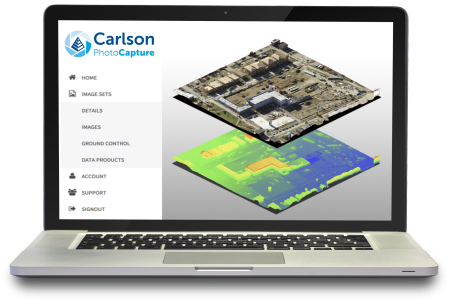
Carlson Photo Capture is a powerful tool for surveyors and engineers, converting aerial, oblique, and terrestrial imagery into precise 3D site models and point clouds.
The software enables instant creation of orthomosaics, digital contours, and volume calculations for cut/fill assessments.
Key features include setting ground control points for high-accuracy mapping, composite mapping from multiple flyovers, and exporting interactive site maps to share with clients or team members anywhere.
Surveyors can capture topographic elevations, calculate mass for project features, and analyze the full 3D layout of land from any camera angle.
Carlson Photo Capture streamlines field work, reduces man-hours, and provides instant, accurate 3D deliverables for survey and construction projects, all viewable and editable through a web interface.
3D Mapping & Modeling
• Convert aerial, oblique, and terrestrial imagery into interactive 3D maps.
• Generate point clouds, orthomosaics, and digital contours.
Accuracy & Control
• Set ground control points to fine-tune survey accuracy.
• Capture precise topographic elevations and site features.
Volume & Site Analysis
• Calculate cut, fill, and feature volumes instantly.
• Measure project mass and spatial layouts for better planning.
Collaboration & Sharing
• Share 3D site maps with clients and team members anywhere.
• Edit and view maps immediately after upload via web app.
Efficiency & Workflow
• Reduce field man-hours with instant processing.
• Composite multiple flyovers to create accurate, comprehensive site models.
Carlson Software is more than just a purchase—it’s a partnership.
With dedicated Regional Managers across the country, free lifetime technical support, and flexible training options to fit any budget, we’re here to support you every step of the way.
Direct Technical Support
• Hours: Monday – Friday, 9 AM – 5 PM
• Email: tim@carlsongs.com
• Telephone: +1 (716) 799-4187